Shared Streets / Exploring the Integration of Urban Design and Transportation Design
Shared Streets / Exploring the Integration of Urban Design and Transportation Design
What is Shared Streets?
The concept of shared streets is not yet clear at the theoretical and practical levels, but it can at least be intuitively understood as the shared use of the same public street (road) space by different street (road) users. This intuitive understanding mainly exposes the ambiguity of the three dimensions of Context, Function and Consensus (Karndacharuk et al. 2014).
- Ambiguity of the Contextual Dimension
This is manifested in the lack of a clearly established relationship with urban planning and urban design, with transportation planning and transportation design, or with both urban and transportation.
- Functional ambiguity
The definition of streets and roads, the definition of separation and integration spaces, and the delineation of public spaces lack rigorous theoretical support and practical tests.
- Ambiguity of consensus dimension
The values of street space activities, policy strategies for urban and transportation development, and expectations and visions under multiple demands have not yet reached a high degree of unity.
International development trends
- Global Street Design Guide
The GlobalStreet Design Guide, published in 2016, is more mature than the Urban Street Design Guide (North American Urban Street Design Guide), published in 2012, noting that several informal commercial or residential shared streets have emerged around the globe, such as Ford Street in New Zealand Ford Street in Auckland, New Zealand and Van Gogh Walk Street in London, England. By removing dedicated space allocated for walking, cycling and motorized vehicles, these streets create a shared-use street where all users are more discreet and respectful of each other.
Commercial Shared Street Design Comparison / Before and After Ford Street Renovation, New Zealand, 2018
Image source: https://globaldesigningcities.org/publication/global-street-design-guide/streets/shared-streets/commercial-shared-streets/case-study-fort-street-auckland-new-zealand/
Key elements of shared streets include the removal of spatial amenities that segregate walking from motorized vehicles, the expansion of activity space to the front of buildings, full right-of-way for pedestrians, the design of unique accessible routes, the removal of parking wherever possible, and the strict limitation of temporary vehicle stops. In addition, commercially oriented shared streets can work together with pedestrian streets to form a vibrant network of public spaces (NACTO and GDCI, 2016).
Before and After Reconstruction of Oakland’s Shared Street Network and Road Space Allocation, 2018
Image source: https://globaldesigningcities.org/publication/global-street-design-guide/streets/special-conditions/post-industrial-revitalization/case-study-jellicoe-st-auckland-new-zealand/
The controlled plan amendment for East Midtown in Midtown Manhattan, which was approved in August 2017, places the creation of public spaces and places of activity as a core objective, uses three tools – pedestrian plazas, shared streets and transit corridors – to plan transportation spaces, redesigns streets and walkways from the perspective of public open space, stimulates the vitality of streets with the help of urban design techniques, and rearranges underutilized spaces to The urban design approach was used to energize the street, reorganize unused space to meet the needs of pedestrians, and redistribute street space to reflect the real needs of various users. The public realm transformation involves 41st Street, 43rd Street, 44th Street, Pershing Square, Vanderbilt Avenue, and Pike Street.

East Midtown Public Space Conceptual Program, 2017
Image source: https://www.nyc.gov/html/dot/downloads/pdf/43rd-street-eastmidtown-shared-street-cb6-may2018.pdf
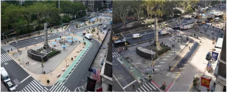
Lower Manhattan’s Flatiron Plaza renovation project on Broadway between 23rd and 24th Streets, on the other hand, is New York’s first true shared street (Department of Transportation of New York City, 2017). A signature project of New York City’s efforts to create world-class streets (Department of Transportation of New York City, 2008), Flatiron Plaza was born out of a street design renovation in 2008. The New York Department of Transportation piloted it as a shared street for the 2016 Car-Free Day event and officially implemented it in early 2017 to further enhance place-based activities in public spaces and pedestrian safety within them.


Flatiron Street 2007, 2008, 2016 and 2017 Street Design Transformation History, 2017
Image source: https://m.thepaper.cn/newsDetail_forward_1708856
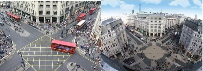
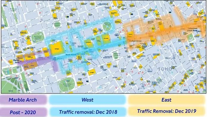
Oxford Circus, a cross-shared street between Oxford Street and Regent Street completed in October 2009, carries the mobility needs of nearly 1,200 motor vehicles and 38,000 people during peak hours [8]. The cross-diagonal design emphasizes absolute priority for walkers, and the flexible crossing pattern provides 30-second walk-only signals every 2-minute cycle, which is more conducive to maintaining the smooth operation of overall traffic. The then Mayor of London, Boris Johnson, commented that it brought a better sense of safety for walkers and cyclists, and that users began to learn to pay attention to each other and trust each other. Despite the fact that in late 2017, the new Mayor Sadiq Khan has decided to fully pedestrianize Oxford Street by 2020 [9], there is still no way to hide the huge contribution that shared streets have made in the past 10 years to change the concept of urban mobility and to improve the quality of services for walking and cycling trips.


Comparison of Oxford Street shared street improvements, 2017
Image source: https://www.onlondon.co.uk/oxford-street-transformation-where-will-all-the-buses-go/
Completing construction in December 2011, Exhibition Road attracts more than 11 million visitors annually [8]. Its shared-space renovation mainly included the installation of a flat pavement without curbs, the removal of street hard separators, Zigzag-style walkway paving, and a 30 km/h speed limit for motor vehicles. As of the end of 2013, when publicly available monitoring data was released, there had not been a single traffic accident on Exhibition Road, and it has served as an effective example of the safety and reliability of shared streets on multiple occasions. However, the October 8, 2017 traffic accident caused by a multi-vehicle collision with 11 injuries caused by an UBER internet car rental brought shared streets back into the controversy about safety and reliability.
Reference List:
Department of Planning of New York City (2017) Greater East Midtown Plan, Land Use. Available at: https://council.nyc.gov/land-use/plans/greater-east-midtown-plan/ (Accessed: 12 March 2024).
Department of Transportation of New York City (2017) Press releases, DOT Press Releases – NYC DOT Announces ‘Shared Street’ Completed in Manhattan’s Flatiron District. Available at: https://www.nyc.gov:443/html/dot/html/pr2017/pr17-059.shtml (Accessed: 12 March 2024).
Departmentof Transportation of New York City (2008) World class streets: Remaking New York City’s public realm. Available at: https://www.nyc.gov/html/dot/downloads/pdf/World_Class_Streets_Gehl_08.pdf (Accessed: 12 March 2024).
Karndacharuk, A., Wilson, D.J. and Dunn, R. (2014) ‘A review of the evolution of shared (street) space concepts in urban environments’, Transport Reviews, 34(2), pp. 190–220. doi:10.1080/01441647.2014.893038 (Accessed: 12 March 2024).
NACTO (2013) Urban Street Design Guide, https://nacto.org/publication/urban-street-design-guide/. Washington: Island Press (Accessed: 12 March 2024).
NACTO and GDCI (2016) Global Street Design Guide, https://globaldesigningcities.org/publication/global-street-design-guide-cn/. Washington: Island Press (Accessed: 12 March 2024).
Transport for London (2016) Better Streets delivered – transport for London. Available at: https://content.tfl.gov.uk/better-streets-delivered-web-version.pdf (Accessed: 12 March 2024).
Transport for London (2017) Have your say on the transformation of Oxford Street – transport … Available at: https://consultations.tfl.gov.uk/roads/oxford-street/?cid=oxford-street (Accessed: 12 March 2024).


Runquan, your exploration of shared streets gives a full overview. They have the potential to revolutionize cities. However, there are additional dimensions worth considering to further understand their impact.
Shared streets aim to make cities better. But, they can be hard for vulnerable groups, like the blind and elderly. Studies indicate that removing old pedestrian infrastructure, like curbs, can create navigation problems. It can also increase the risk of accidents for these populations (Imrie & Kumar, 2020). Shared streets foster inclusivity and interaction. But, it is crucial to add design elements. They must ensure the safety of all users. Implementing tactile paving and audio signals can mitigate these risks (Greed, 2011).
Also, the success of shared streets depends on user behavior and local context. For instance, Oxford Circus and Exhibition Road in London have seen positive outcomes. But, these areas benefited from strong public awareness campaigns. They also benefited from strong enforcement (Moody & Melia, 2014). In contrast, areas with looser management do not yield the same benefits. Thus, applying shared street principles to city’s unique cultures and behaviors is essential. It is key for their effective use.
Furthermore, examining international case studies reveals mixed results. The Dutch have had great success with “woonerf” (living streets). They have reduced traffic speeds and increased community interactions (van der Zee, 2015). However, in New York, projects like Flatiron Plaza have succeeded. But, they have faced challenges with traffic. They also struggle to enforce shared space rules (NYC DOT, 2017). These examples show the need for custom approaches. They also show the need for ongoing monitoring to address new issues.
In conclusion, shared streets hold great promise. But, their design must consider the needs of all users and fit local contexts. Adding inclusive design features and ongoing community engagement are critical. They maximize the benefits and ensure urban spaces are safe and accessible.
References:
1.Greed, C. (2011). Inclusive Urban Design: Streets For Life. Routledge.
2.Imrie, R. & Kumar, M. (2020). “The Impact of Shared Spaces on the Mobility of Disabled People”. Disability & Society, 35(4), pp. 573-594.
3.Moody, S., & Melia, S. (2014). “Shared Space: Research, Policy and Problems”. Proceedings of the Institution of Civil Engineers – Transport, 167(6), pp. 384-392.
4.NYC Department of Transportation (NYC DOT) (2017). Flatiron Shared Street Evaluation. Available at: https://www.nyc.gov/html/dot/downloads/pdf/flatiron-shared-street-evaluation-2017.pdf
5.van der Zee, R. (2015). “How the Dutch Got Their Cycle Paths”. The Guardian. Available at: https://www.theguardian.com/cities/2015/may/05/how-dutch-got-their-cycle-paths