Core principles and Design strategies for creating flood-resilient environments.
Climate change and rising sea levels are affecting the design and structure of cities. Edward Barsley, the author of Retrofitting for Flood Resilience, provides six key methods in his book for modifying urban and natural areas to minimize the impact of flooding. He believes that flood-resistant design can significantly reduce the exposure and vulnerability of communities and the environment to flooding, and can help those affected recover more quickly. Therefore, flood-resistant design should be seen as an opportunity to improve cities, rather than just a necessity.
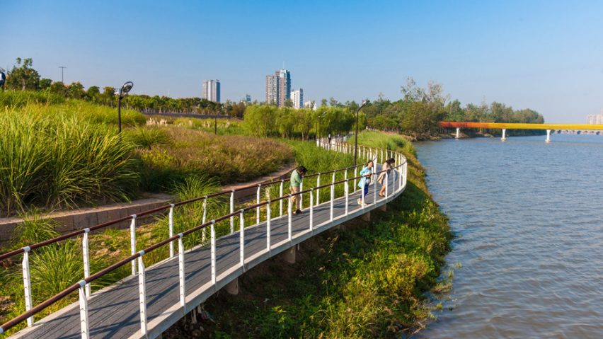
Figure 1: Riverfront access (https://www.outdoordesign.com.au/news-info/exemplary-projects/a-resilient-landscape/1073.htm)
Barsley, who runs The Environmental Design Studio, urges architects to consider how they can positively impact these environments, given that the severity and frequency of flooding events are increasing due to climate change. He states that urgent collective action is needed, particularly since by 2025, three-quarters of the world’s population will be living in coastal areas that are exposed or vulnerable to flooding.
Barsley suggests that architects can bring about change on various levels and that they should be aware of the different techniques available to enhance the resilience of both the natural and built environment.

Figure 2: Essential criteria’s for River front urban redevelopment per-suing climate and physical parameters as a part of the flood risk management. (https://www.dezeen.com/2018/10/23/scape-resilient-boston-harbor-plan
Figure 3: The creation of a framework for implementing landscape and greenspace indicators in sustainable urban planning is essential for the successful management of waterfront landscapes. This framework can assist in evaluating the effectiveness of landscape and greenspace management practices, provide a basis for making informed decisions, and help identify areas for improvement. The inclusion of such indicators in urban planning can lead to more sustainable and environmentally friendly development.
(https://nclurbandesign.org/wp-admin/post-new.php)
He categorizes flood risk management strategies into six spatial tactics: attenuate, alleviate, restrict, realign, create, and embrace. He stresses that there is no one-size-fits-all solution to flooding, as each type of flooding has distinct characteristics that influence the suitability of a design approach. Therefore, every approach should be tailored to suit its specific context, taking into account various factors such as construction materials, housing types, ground conditions, conservation policies, and user preferences.
Restrict – BIG U by BIG
The “restrict” approach is focused on reducing the potential harm caused by floods by utilizing a combination of hard and soft measures to prevent water from entering the community.

Figure 4: Creating a micro climate to enrich the quality of public spaces. (https://www.tredjenatur.dk/en/portfolio/the-first-climate-district/)
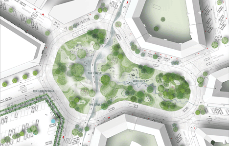
Figure 5: Plan of the green infrastructure. (https://www.tredjenatur.dk/en/portfolio/the-first-climate-district/)
An example of this approach can be seen in BIG’s BIG U project, which is a 16-kilometer-long system being built in New York City to protect Manhattan from flooding.
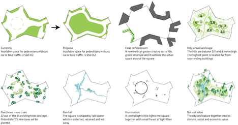
Figure 6: Planning strategies. (https://www.tredjenatur.dk/en/portfolio/the-first-climate-district/)
The system is designed to meet the unique needs and requirements of each neighborhood at different scales, and it incorporates a range of programs and functions.

Figure 7: Views of the street. (https://www.tredjenatur.dk/en/portfolio/the-first-climate-district/)
Resilient Boston Harbor by SCAPE- Embrace
The approach known as “embrace” involves accepting water as a significant element in a project and utilizing it as a catalyst for design to arrange and adapt the built and natural environment accordingly.
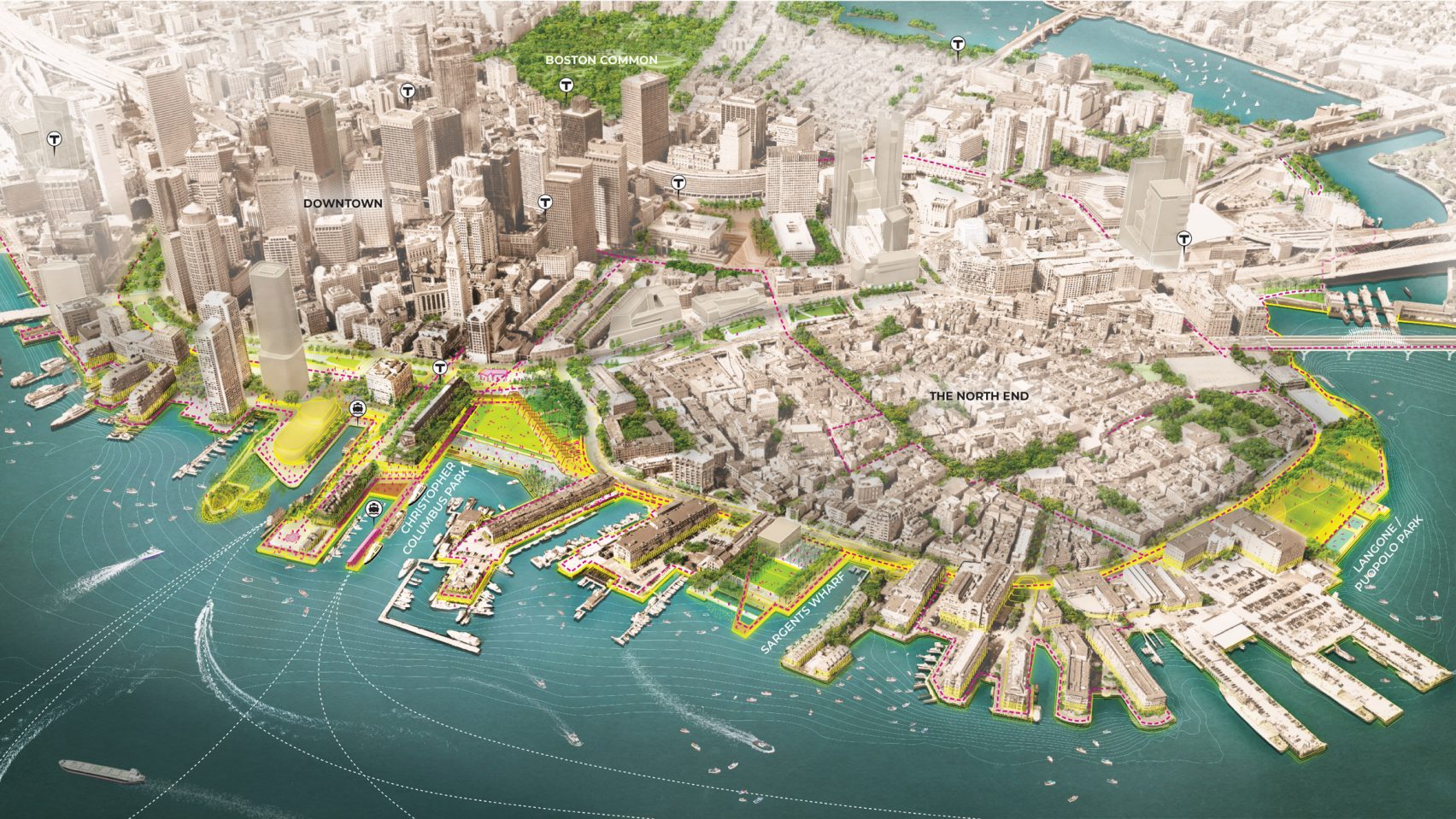
Figure 8: SCAPE has created visuals for its Resilient Boston Harbor plan, featuring lime green zones representing elevated landscape (https://www.dezeen.com/2018/10/23/scape-resilient-boston-harbor-plan-flood-defences-rising-sea-levels-climate-change/)
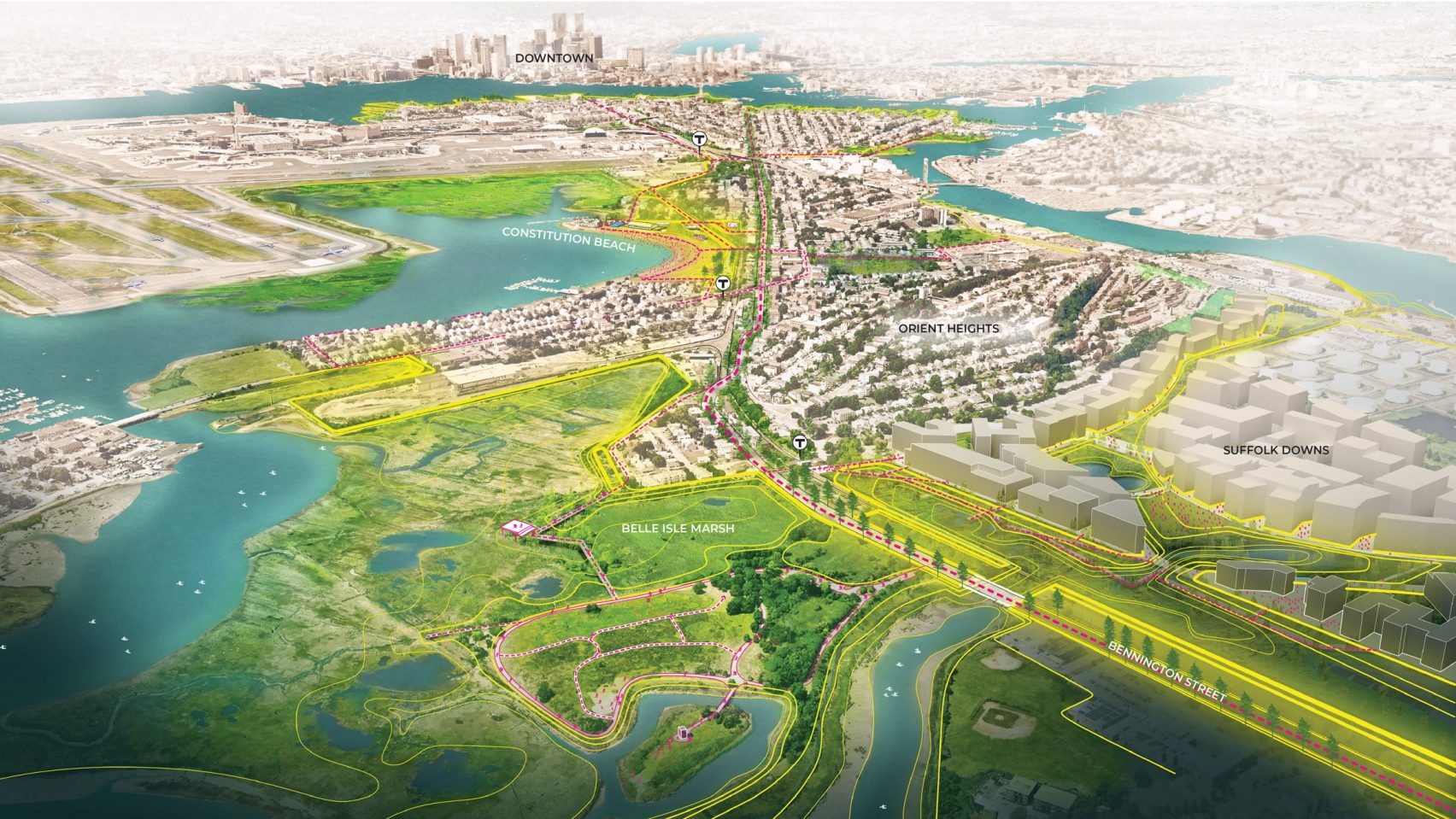
Figure 9: For East Boston, marshlands at Belle Isle will be restored to buffer the shoreline, with other new connections and access points marked by pink dashes. (https://www.dezeen.com/2018/10/23/scape-resilient-boston-harbor-plan-flood-defences-rising-sea-levels-climate-change/)
This approach is exemplified by SCAPE’s partnership with the City of Boston to develop a plan for a “Resilient Boston Harbor.”
Figure 10: Resilient Boston Harbor: Downtown, Christopher Columbus park and long wharf. (https://www.dezeen.com/2018/10/23/scape-resilient-boston-harbor-plan-flood-defences-rising-sea-levels-climate-change/)
The project includes the implementation of raised landscapes, protective parks, and durable retrofits of vulnerable buildings to increase the area’s flood resilience.
Saint Kjeld’s Kvarter by Tredje Natur- Attenuate
The “embrace” approach recognizes that water will be a critical element in a project and uses it as a stimulus for design to adapt and reorganize the built and natural environment appropriately.
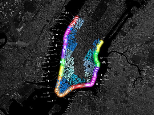
Figure 12: Zoning and strategies. (https://www.architectmagazine.com/project-gallery/the-big-u-6280)

Figure 13: Active Riverfront remedies at Saint Kjeld’s Kvarter. (https://www.architectmagazine.com/project-gallery/the-big-u-6280)
An example of this method is demonstrated in SCAPE’s partnership with the City of Boston to develop a plan for a “Resilient Boston Harbor,” which includes the implementation of elevated landscapes, protective parks, and retrofitting vulnerable buildings to increase the area’s resilience to flooding.

Figure 14: Phase one at Saint Kjeld’s Kvarter. (https://www.architectmagazine.com/project-gallery/the-big-u-6280)
Additional references:
https://www.outdoordesign.com.au/news-info/exemplary-projects/a-resilient-landscape/1073.htm
SCAPE contributes to Resilient Boston Harbor flood-protection project
https://www.architectmagazine.com/project-gallery/the-big-u-6280


