
I have benefited a lot from your article, thank you for sharing the Cheonggyecheon project in Korea and letting me know the fascination of urban blue-green system. As the origin of human civilisation, rivers have witnessed the journey of mankind from agricultural society to industrial society, and they play an extremely important role in the process of urban development, with a variety of values such as the provision of water sources, transport corridors, landscapes, and ecology. Nowadays, as an important link in the blue-green system of cities, rivers influence the regional water cycle, so how to optimise and enhance the social and ecological value of rivers is an urgent consideration for urban designers. In China, the Three Gorges Project, Dujiangyan Project and other extremely successful and world-renowned water conservancy projects have brought countless values to the surrounding areas and residents. In my hometown, the government-led ‘Five Water Control’ project has integrated and sorted out the water network system in the region, detailed the river management to government departments, optimised the flood prevention and flood resistance of the river, and planted aquatic landscape vegetation in the river to enhance the quality of the river and its surroundings, and the citizens are increasingly enjoying their time in and around the river. the surrounding open space for leisure.
Opening Rivers
Historically, rivers and streams have played a vital role in shaping cities, serving as sources of water, routes for trade, and natural barriers for defense. However, urbanization brought significant challenges to these waterways (Knoll, Lübken, & Schott, 2017). As Varley (2024) explains, the industrialization of cities, particularly during the 19th and early 20th centuries, led to rivers being diverted into underground channels to facilitate development and mitigate flooding risks. This transformation profoundly altered the role of rivers in urban landscapes. A striking example of this is found in the 1870 report of the Rivers Pollution Commission in Britain, which included a facsimile of a letter written not with ink, but with the darkened, polluted waters of the river Irwell, the notorious stream running through Lancashire and Manchester (Castonguay & Evenden, 2012).
The Reasons Behind River Covering
- Flood Control: Many cities lacked advanced flood management systems during periods of rapid growth. Encasing rivers in culverts or underground tunnels was seen as a practical way to reduce seasonal flooding risks (Knoll, Lübken, & Schott, 2017).
- Land Availability: As urban populations grew, the demand for land intensified. Rivers, occupying valuable real estate, were often buried to make way for infrastructure and housing (Clifford in Urban Rivers: Remaking Rivers, Cities, and Space in Europe and North America, 2012).
- Sanitation: In the past, rivers were used as waste disposal systems, and their open exposure led to unpleasant odors and unsanitary conditions. Covering them helped mitigate these public health concerns, especially in rapidly industrializing cities. (Naturally Resilient Communities, n.d.)
- Functionality: Over time, the aesthetic and ecological value of rivers was overshadowed by their perceived inconvenience. Urban planners prioritized engineering solutions, burying rivers beneath expanding cities (Castonguay & Evenden, 2012).
Calls for Reopening Urban Rivers
The growing environmental movement has brought attention to the benefits of reopening urban rivers, a process often referred to as “daylighting.” This approach brings buried waterways back to the surface, offering diverse ecological, social, and economic advantages. As Pinkham (2000) outlines, daylighting can address both practical urban challenges and broader environmental goals:
Environmental and Hydraulic Advantages:
- Daylighting mitigate flooding by expanding hydraulic capacity and restoring natural floodplains, reducing erosion through natural stream dynamics.
- Exposed waterways improve water quality by allowing sunlight, vegetation, and soil to neutralize pollution. They also reduce the burden on sewer systems by diverting runoff.
- Restored streams recreate habitats for aquatic life and wildlife corridors, enhancing biodiversity.
Community and Economic Benefits:
- Open streams beautify urban areas, boost property values, and create green spaces for recreation.
- Daylighting is often less expensive than replacing aging culverts and simplifies maintenance.
- Restored waterways attract visitors, benefiting local businesses and creating jobs.
Reconnection with Nature
- Daylighting reconnects people with natural ecosystems, fostering environmental awareness and offering the satisfaction of “setting right something we messed up” (Pinkham, 2000).


Challenges to Daylighting
Daylighting projects, as highlighted by Pinkham (2000), introduce complexities that go beyond those of standard surface stream restorations, requiring innovative approaches to overcome unique obstacles:
- Extensive Earthmoving and Costs: Removing culverts and constructing new channels often involve significant excavation, grading, and disposal of spoils, adding to project expenses.
- Space Limitations: Unlike surface stream restorations, daylighting is often constrained by limited urban space, hindering the creation of natural channel geometries and riparian corridors.
- Historical and Geographical Challenges: Identifying the original channel location may require detailed historical research and soil analysis to align the new channel with upstream and downstream characteristics.
- Hydraulic Integration: Daylighting projects must carefully address downstream connections, ensuring seamless integration with urban stormwater systems.
- Community Awareness and Resistance: Buried streams are often invisible to the public, requiring significant outreach to highlight their potential. Concerns about safety, flooding, or regulatory burdens can pose additional hurdles.
- Political and Social Considerations: Urban density and competing land uses can make daylighting politically sensitive, but the prospect of reviving lost natural features often generates enthusiasm and support.
Examples of River Reopening Projects
1. The Cheonggyecheon Stream in Seoul, South Korea
One of the most famous river reopening projects, the Cheonggyecheon stream was once covered by a highway. In 2003, the city of Seoul undertook a massive project to remove the highway and restore the stream, creating a 5.8-kilometer-long green space that revitalized the surrounding areas. The project improved local air quality, provided a habitat for wildlife, and became a popular recreational space for residents and tourists alike (Cheonggyecheon Restoration Project, 2024).


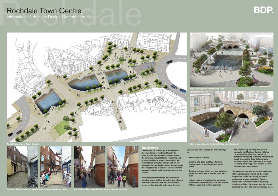
2. River Reopening in Rochdale, UK
A notable example of a river restoration project in the United Kingdom is the ‘daylighting’ of the River Roch in Rochdale. This initiative uncovered sections of the river that had been concealed beneath the town center for over a century. The project not only revitalized the urban landscape but also revealed a historic medieval bridge, enhancing the area’s cultural heritage. The restoration has provided environmental benefits, including improved flood management and the creation of new public spaces.
Conclusion
The movement to reopen covered rivers is a critical step towards creating more sustainable, livable cities. While the challenges of space, cost, and engineering are significant, especially in urban environments where high property values and dense infrastructure constrain restoration options, the long-term benefits—from ecological restoration to enhanced quality of life—make it a worthwhile investment.
To be effective, daylighting must be integrated into broader catchment management strategies. As Bernhardt and Palmer (2007) highlight, the key challenge lies in determining when restoration efforts are feasible, and when they should aim for ecological improvements within the constraints of urbanization. By learning from successful global case studies, cities can design nature-based solutions that address urban flooding, climate change, and ecosystem degradation, while simultaneously revitalizing urban landscapes and reconnecting citizens with their natural heritage.
References:
- Varley, D. (2024) Introduction to Blue Green Newcastle (Lecture). TCP8090: Principles of Urban Design. Newcastle University.
- Naturally Resilient Communities (n.d.) Daylighting Rivers and Streams. Available at: https://nrcsolutions.org/daylighting-rivers/ (Accessed: 06/11/2024).
-
Cheonggyecheon Restoration Project (2024) Available at: https://udcsa.gsd.harvard.edu/projects/9 (Accessed: 08/11/2024).
- Bernhardt, E. S., & Palmer, M. A. (2007). Restoring Streams in an Urbanizing World. Freshwater Biology. Available at: https://www.researchgate.net/publication/227633870_Restoring_Streams_in_an_Urbanizing_World, (Accessed 03/01/2025)
- Pinkham, R. (2000) Daylighting: New Life for Buried Streams. Available at: https://secure.wetlandstudies.com/resources-regulations/documents/Daylighting_NewLifeForBuriedStreams.pdf (Accessed 06/01/2025)
- Castonguay, S., & Evenden, M. (2012). Urban Rivers: Remaking Rivers, Cities, and Space in Europe and North America. Available at: https://www-jstor-org.libproxy.ncl.ac.uk/stable/j.ctv10tq43d (Accessed 06/01/2025)
- Knoll, M., Lübken, U., & Schott, D. (2017). Rivers Lost, Rivers Regained: Rethinking City-River Relations. Available at: https://www-jstor-org.libproxy.ncl.ac.uk/stable/j.ctv10tq43d (Accessed 04/01/2025)
- Kadinsky, S. (2016) Rochdale Daylighting. Available at: https://hiddenwatersblog.wordpress.com/2016/04/11/rochdale-daylighting/ (Accessed: 05/01/2025).
Image References
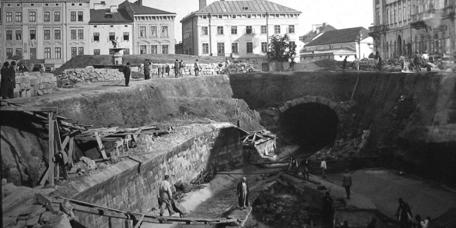
Image 1. TDB (1870) Available at: https://forgottengalicia.com/lvivs-underground-river-the-poltva/#pll_switcher (Accessed: 06/01/2025).
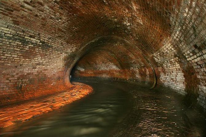
Image 2. TDB (n.d) The Poltva River – buried beneath Lviv. Available at: https://forgottengalicia.com/lvivs-underground-river-the-poltva/#pll_switcher (Accessed: 06/01/2025).
Image 3. Morton, D. (2022) The great storm of 2012: Recalling ‘Thunder Thursday’ in 20 photographs 10 years on. Available at: https://www.chroniclelive.co.uk/news/history/gallery/great-storm-2012-recalling-thunder-24333097 (Accessed: 07/11/2024).
Image 4. Purucker, E. (2006) TGrenzenlose Landesgartenschau 2006 in Marktredwitz: Wasserspielplatz am wieder freigelegten Lohbach.. Available at: https://www.fichtelgebirge-oberfranken.de/marktredwitz/wasserspielplatz2.htm (Accessed: 08/11/2024).
Image 5. TDB (n.d) Cheonggyecheon River in XX century. Available at: https://udcsa.gsd.harvard.edu/projects/9 (Accessed: 08/11/2024).
Image 6. TDB (2003) The elevated freeway prior to the 2003 start of construction on the stream restoration project. Available at: https://udcsa.gsd.harvard.edu/projects/9 (Accessed: 08/11/2024).
Image 7. TDB (2005) The restored Cheonggyecheon Stream after construction was complete. Available at: https://udcsa.gsd.harvard.edu/projects/9 (Accessed: 08/11/2024).
Image 8. Kim, J. (2023) Gwangtong Bridge is a restored piece of history along the Cheonggyecheon. Available at: https://udcsa.gsd.harvard.edu/projects/9 (Accessed: 08/11/2024).
Image 9. BDP (2014) Available at: https://hiddenwatersblog.wordpress.com/2016/04/11/rochdale-daylighting/ (Accessed: 04/01/2025).
I have benefited a lot from your article, thank you for sharing the Cheonggyecheon project in Korea and letting me know the fascination of urban blue-green system. As the origin of human civilisation, rivers have witnessed the journey of mankind from agricultural society to industrial society, and they play an extremely important role in the process of urban development, with a variety of values such as the provision of water sources, transport corridors, landscapes, and ecology. Nowadays, as an important link in the blue-green system of cities, rivers influence the regional water cycle, so how to optimise and enhance the social and ecological value of rivers is an urgent consideration for urban designers. In China, the Three Gorges Project, Dujiangyan Project and other extremely successful and world-renowned water conservancy projects have brought countless values to the surrounding areas and residents. In my hometown, the government-led ‘Five Water Control’ project has integrated and sorted out the water network system in the region, detailed the river management to government departments, optimised the flood prevention and flood resistance of the river, and planted aquatic landscape vegetation in the river to enhance the quality of the river and its surroundings, and the citizens are increasingly enjoying their time in and around the river. the surrounding open space for leisure.
Thank you! The sources seem reliable to me, but let me know if there’s a specific part you’re unsure about—I’d be happy to clarify further.
In a addition I love BIG U, BIG’s project for the Manhattan coast in the U.S. BIG U is designed to encircle the Manhattan coast from West 54th Street to East 40th Street and is presented as a series of protective landscaped strips that protect neighbourhoods from storm water and sea level rise, while providing much-needed local cultural, recreational and socio-economic benefits. As crazy as it sounds, the BIG U concept came about during Mayor Bloomberg’s Special Initiative for Redevelopment and Resiliency. In response to the need for a 4.2-metre (14-foot) high protective barrier and a standard, featureless breakwater design, the landscape architects envisioned a distinctive approach: protective infrastructure that enriches the waterfront, habitat, and relationship with the upland community. The firm outlined a range of innovative approaches: a landscaped berm with seagrass, a levee that doubles as a skate park and amphitheatre, and a seawall that hosts a pop-up café and passive recreation. These multi-dimensional designs expand into a hedonic and sustainable vision that could avoid over a billion dollars in future climate change related damages, while creating new economic opportunities, tourist destinations, social service institutions and recreational spaces that will help shape the future of the city.
I have benefited a lot from your article, thank you for sharing the Cheonggyecheon project in Korea and letting me know the fascination of urban blue-green system. As the origin of human civilisation, rivers have witnessed the journey of mankind from agricultural society to industrial society, and they play an extremely important role in the process of urban development, with a variety of values such as the provision of water sources, transport corridors, landscapes, and ecology. Nowadays, as an important link in the blue-green system of cities, rivers influence the regional water cycle, so how to optimise and enhance the social and ecological value of rivers is an urgent consideration for urban designers. In China, the Three Gorges Project, Dujiangyan Project and other extremely successful and world-renowned water conservancy projects have brought countless values to the surrounding areas and residents.(Liu,2019) In my hometown, the government-led ‘Five Water Control’ project has integrated and sorted out the water network system in the region, detailed the river management to government departments, optimised the flood prevention and flood resistance of the river, and planted aquatic landscape vegetation in the river to enhance the quality of the river and its surroundings, and the citizens are increasingly enjoying their time in and around the river. the surrounding open space for leisure.(Zhang,2022)
And of course I love BIG U, BIG’s project for the Manhattan coast in the U.S. BIG U is designed to encircle the Manhattan coast from West 54th Street to East 40th Street and is presented as a series of protective landscaped strips that protect neighbourhoods from storm water and sea level rise, while providing much-needed local cultural, recreational and socio-economic benefits. As crazy as it sounds, the BIG U concept came about during Mayor Bloomberg’s Special Initiative for Redevelopment and Resiliency. In response to the need for a 4.2-metre (14-foot) high protective barrier and a standard, featureless breakwater design, the landscape architects envisioned a distinctive approach: protective infrastructure that enriches the waterfront, habitat, and relationship with the upland community. The firm outlined a range of innovative approaches: a landscaped berm with seagrass, a levee that doubles as a skate park and amphitheatre, and a seawall that hosts a pop-up café and passive recreation. These multi-dimensional designs expand into a hedonic and sustainable vision that could avoid over a billion dollars in future climate change related damages, while creating new economic opportunities, tourist destinations, social service institutions and recreational spaces that will help shape the future of the city.(REDUILD BY DESIGN2022)
Reference:
Liu, X., Qu, G., Guo, X. and Yue, H. (2019). Study on the Three Gorges reservoir flood control operation chart considering comprehensive utilization requirements. IOP Conference Series: Earth and Environmental Science, 304(No data), p.042040.doi:https://doi.org/10.1088/1755-1315/304/4/042040.
Zhang, N., Zhang, L., Liu, C. and Lu, W. (2022). Study on the Influence of Smart Water and Public Participation on Water Environment Governance: Based on the Investigation of‘Five Water Joint Governance’in Zhejiang Province. Resources and Environment in the Yangtze Basin, Vol.31 No.9(1004-8227( 2022) 09-2011-11). doi:https://doi.org/10.%2011870%20/cjlyzyyhj202209013.
REBUILD BY DESIGN. (2022). THE BIG U. [online] Available at: https://rebuildbydesign.org/work/funded-projects/the-big-u/ [Accessed 18 Dec. 2024].
“Rivers and streams have played a vital role in shaping cities, serving as sources of water, routes for trade, and natural barriers for defense…” As mentioned in the very beginning of your writing, water bodies alteration project reflects an urban growth / decline, this subject coincidentally has been one of my interest in last thesis and I would like to elaborate further on cultural or historical impact with a few more projects back in the 1900s.
In the 1900s and earlier, rivers served as the foundation for settlements to emerge and thrive thus have always been major factor in founding a new country or city. “A beautiful city that is quite literally surrounded by an open-air sewage system…” (Steven,2013) Where else could be on our mind other than Venice? A city born from 124 islands in a marshy lagoon, deeply vulnerable and reliant on surrounding water-bodies. The strategic location and the Venetian architecture that is born from the intricate channeling of canals has pushed it to it’s Everest by the late 13th century. However, years of battling and negotiating with the water, masked behind the propagated fashion by tourism strategy are the “comeuppance” suffered by the city that has become “the joy of the tourists.” Pollution, disastrous acque alte that accelerates sinking. It is the “half charmed, half ironic” (Davis, Robert C., and Garry R. Marvin,2012) situation experienced by Venice today. Venice is not liveable anymore, (Giacomo-Maria. S & Antonio. R, (2020)) here comes 2025 and we shall witness the if the MOSE project could save the Venetian from grasping. “A city can die when the inhabitants themselves lose their memory and become foreigners in their own city.” (Settis, 2014)
Putting politics aside, Ellis Sylvester reversing the flow of Chicago River might sound absurd however the attempt was hailed as a public health and engineering triumph in the 1800s and sooner crowned Chicago as the the first large American city to build a comprehensive sewer system. (Kearney, Joseph D, 2021)
Water belongs to nature; it is a double edged sword, could be the saving grace or the fatal fall in one city.
While feeling helpless on Venice consequences, the rivers in Providence, of what we can describe revived, has recreated the entire city. River was covered due to the declining needs of waterways enetring the rail-driven economy. “Potential use of the rivers for transportation and recreation [was] permanently lost” (Heeju, n.d.) in later iterations of the Capital Center Plan, which called for three new bridges over Memorial Boulevard and left 1,147 contiguous feet of existing bridge decking in place, and the river covered by the widest bridge in the world as listed in the Guinness Book of World Records. Resonated with Llebues Woods’ claim of “highway connects city but separated neighbourhood”, the intervention leaves the downtown disconnected and historical sites abandoned and forgotten. Luckily, sooner the major city-revitalizing project to reintroduce the long-abandoned rivers and undo what has done to it. Revitalization of the city happened through development its culture and arts around the river. Through the relocation of river new uses were introduced for instance annual festival like “WaterFire Providence” was introduced to celebrate moving renaissance of Providence bestow by the river. Providence river has exceeded its being; rather than just a way water run through, but a more crucial place to Providence’s history and development.
In my point of view, this blog has enlighten me to investigate the duality of river manipulation and the reciprocal influences between the formation of river and settlements surrounding. Comparing Venice with the other two precedents, the evolution of water bodies often reveals a deep cultural connection that transcends mere social and environmental impact (though these are often the drivers of such projects) when approached with greater thoughtfulness. To conclude, I believe every features in one city holds one’s personal memory that contributes to it’s cultural identity. River, as a gift of nature should always be treated with respect and care, rather taking it for granted.
References
1.Kearney, Joseph D., and Thomas W. Merrill, ‘Reversing the Chicago River’, Lakefront: Public Trust and Private Rights in Chicago (Ithaca, NY, 2021; online edn, Cornell Scholarship Online, 23 Sept. 2021), https://doi.org/10.7591/cornell/9781501754654.003.0006, accessed 10 Dec. 2024.
2.Davis, Robert C., and Garry R. Marvin, ‘Dangerous Waters’, Venice, the Tourist Maze: A Cultural Critique of the World’s Most Touristed City (Oakland, CA, 2004; online edn, California Scholarship Online, 22 Mar. 2012), https://doi.org/10.1525/california/9780520238039.003.0009, accessed 12 Dec. 2024.
3. Christine, A. Klein, and Sandra Z., ‘Mississippi River Tragedies: A Century of Unnatural Disaster’ (New York, NY, 2014; online edn, NYU Press Scholarship Online, 24 Mar. 2016), https://doi.org/, accessed 12 Dec. 2024.
4.Marshall, Philip. “Railroads and Rivers .” Phillip C. Marshall. Phillip C. Marshall, 01 Oct 2012.
5.Samuel A. Coren, ‘The Stony Preserve of Orphaned Symbols: Urban Planning and the Spatial Transformations of Downtown Providence, Rhode Island: 1959-2000’ Rhode Island College, 2015.
6.Cain, Louis P. Sanitation Strategy for a Lakefront Metropolis: The Case of Chicago. 1978.
7.Cain, Louis P. “The Search for an Optimum Sanitation Jurisdiction: The Metropolitan Sanitary District of Greater Chicago, A Case Study,” Public Works Historical Society. 1980.
8.Giacomo-Maria Salerno & Antonio Paolo Russo (2020): Venice as a short-
term city. Between global trends and local lock-ins, Journal of Sustainable Tourism, https://doi.org/10.1080/09669582.2020.1860068
“Rivers and streams have played a vital role in shaping cities, serving as sources of water, routes for trade, and natural barriers for defense…” As mentioned in the very beginning of your writing, water bodies alteration project reflects an urban growth / decline, this subject coincidentally has been one of my interest in last thesis and I would like to elaborate further on cultural or historical impact with a few more projects back in the 1900s.
In the 1900s and earlier, rivers served as the foundation for settlements to emerge and thrive thus have always been major factor in founding a new country or city. “A beautiful city that is quite literally surrounded by an open-air sewage system…” (Steven,2013) Where else could be on our mind other than Venice? A city born from 124 islands in a marshy lagoon, deeply vulnerable and reliant on surrounding water-bodies. The strategic location and the Venetian architecture that is born from the intricate channeling of canals has pushed it to it’s Everest by the late 13th century. However, years of battling and negotiating with the water, masked behind the propagated fashion by tourism strategy are the “comeuppance” suffered by the city that has become “the joy of the tourists.” Pollution, disastrous acque alte that accelerates sinking. It is the “half charmed, half ironic” (Davis, Robert C., and Garry R. Marvin,2012) situation experienced by Venice today. Venice is not liveable anymore, (Giacomo-Maria. S & Antonio. R, (2020)) here comes 2025 and we shall witness the if the MOSE project could save the Venetian from grasping. “A city can die when the inhabitants themselves lose their memory and become foreigners in their own city.” (Settis, 2014)
Putting politics aside, Ellis Sylvester reversing the flow of Chicago River might sound absurd however the attempt was hailed as a public health and engineering triumph in the 1800s and sooner crowned Chicago as the the first large American city to build a comprehensive sewer system. (Kearney, Joseph D, 2021)
Water belongs to nature; it is a double edged sword, could be the saving grace or the fatal fall in one city.
While feeling helpless on Venice consequences, the rivers in Providence, of what we can describe revived, has recreated the entire city. River was covered due to the declining needs of waterways enetring the rail-driven economy. “Potential use of the rivers for transportation and recreation [was] permanently lost” (Heeju, n.d.) in later iterations of the Capital Center Plan, which called for three new bridges over Memorial Boulevard and left 1,147 contiguous feet of existing bridge decking in place, and the river covered by the widest bridge in the world as listed in the Guinness Book of World Records. Resonated with Llebues Woods’ claim of “highway connects city but separated neighbourhood”, the intervention leaves the downtown disconnected and historical sites abandoned and forgotten. Luckily, sooner the major city-revitalizing project to reintroduce the long-abandoned rivers and undo what has done to it. Revitalization of the city happened through development its culture and arts around the river. Through the relocation of river new uses were introduced for instance annual festival like “WaterFire Providence” was introduced to celebrate moving renaissance of Providence bestow by the river. Providence river has exceeded its being; rather than just a way water run through, but a more crucial place to Providence’s history and development.
In my point of view, this blog has enlighten me to investigate the duality of river manipulation and the reciprocal influences between the formation of river and settlements surrounding. Comparing Venice with the other two precedents, the evolution of water bodies often reveals a deep cultural connection that transcends mere social and environmental impact (though these are often the drivers of such projects) when approached with greater thoughtfulness. To conclude, I believe every features in one city holds one’s personal memory that contributes to it’s cultural identity. River, as a gift of nature should always be treated with respect and care, rather taking it for granted.
Reference:
1.Kearney, Joseph D., and Thomas W. Merrill, ‘Reversing the Chicago River’, Lakefront: Public Trust and Private Rights in Chicago (Ithaca, NY, 2021; online edn, Cornell Scholarship Online, 23 Sept. 2021), https://doi.org/10.7591/cornell/9781501754654.003.0006, accessed 10 Dec. 2024.
2.Davis, Robert C., and Garry R. Marvin, ‘Dangerous Waters’, Venice, the Tourist Maze: A Cultural Critique of the World’s Most Touristed City (Oakland, CA, 2004; online edn, California Scholarship Online, 22 Mar. 2012), https://doi.org/10.1525/california/9780520238039.003.0009, accessed 12 Dec. 2024.
3. Christine, A. Klein, and Sandra Z., ‘Mississippi River Tragedies: A Century of Unnatural Disaster’ (New York, NY, 2014; online edn, NYU Press Scholarship Online, 24 Mar. 2016), https://doi.org/, accessed 12 Dec. 2024.
4.Marshall, Philip. “Railroads and Rivers .” Phillip C. Marshall. Phillip C. Marshall, 01 Oct 2012.
5.Samuel A. Coren, ‘The Stony Preserve of Orphaned Symbols: Urban Planning and the Spatial Transformations of Downtown Providence, Rhode Island: 1959-2000’ Rhode Island College, 2015.
6.Cain, Louis P. Sanitation Strategy for a Lakefront Metropolis: The Case of Chicago. 1978.
7.Cain, Louis P. “The Search for an Optimum Sanitation Jurisdiction: The Metropolitan Sanitary District of Greater Chicago, A Case Study,” Public Works Historical Society. 1980.
8.Giacomo-Maria Salerno & Antonio Paolo Russo (2020): Venice as a short-
term city. Between global trends and local lock-ins, Journal of Sustainable Tourism, https://doi.org/10.1080/09669582.2020.1860068