Designing with green infrastructures for climate-proof urban regeneration
In our first class of the term, we travelled to a design site on the south bank of the River Tyne to conduct research. In order to manage flooding during this design project, we had to take into account the threats that flooding on both banks of the River Tyne posed. In this entry, I will describe how green infrastructure may reduce flooding and promote urban development.
1. What is green infrastructure?
Green Infrastructure (GI) is a network of multi-functional green and blue spaces and other natural features of various scales (National Planning Policy Framework, 2021). Open areas such as parks and gardens, forests, fields, hedges, lakes, ponds, playing fields, and coastal habitats, as well as pathways, cycleways, or rivers, are examples of green infrastructure assets. Blue infrastructure refers to assets that involve water, while the phrase “green infrastructure” encompasses all of these. The notion of GI has mostly been used in urban contexts to enhance city planning and ensure that advantages of natural capital are provided in urban systems predominately composed of constructed regions. It is a method of landscape and urban design that tries to blend natural elements into the built environment and utilise them to solve a variety of environmental and social problems.
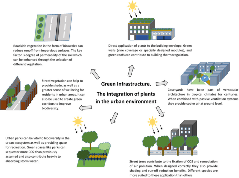
fig1:https://www.researchgate.net/profile/Yangang-Xing 2/publication/310473795/figure/fig2/AS:433339682299909@1480327639949/Examples-of-urban-green-infrastructure-and-their-potential-contributions-to-the-health.png
2. How can green infrastructure increase urban flood resilience?
GI is an approach that is becoming increasingly popular for concurrently addressing concerns associated with urbanisation and environmental change, and it is particularly effective in making cities more flood-resistant. Due to its numerous good functions and consequences, like as biodiversity preservation, water quality, air quality, climate change mitigation through carbon sequestration, and urban flood management through stormwater reductions, GI has emerged as a solution to boost urban flood resilience (Demuzere et al. 2014).
GI reduces runoff b
y capturing and storing rainwater where it falls. Traditional infrastructure, such as concrete pavements and gutters, cannot absorb water and instead funnels it to storm drains and sewer systems. During heavy rainfall events, storm drains and sewer systems can become overwhelmed and cause flooding. GI features, such as rain gardens, bioswales, and green roofs, capture and store rainwater on-site, allowing it to be slowly released into the ground or local waterways. By reducing the amount of water that enters the stormwater system, green infrastructure reduces the risk of flooding during heavy rainfall events.
GI also mitigates flooding by reducing the peak flow of stormwater runoff. Peak flow is the maximum rate at which water flows through a drainage system. During heavy rainfall events, peak flows can cause flooding and erosion in urban waterways. GI features, such as detention basins and constructed wetlands, can reduce peak flows by slowing down the rate at which water enters the stormwater system. These features store water temporarily and slowly release it over time, reducing the impact of peak flows on urban waterways and reducing the risk of flooding.
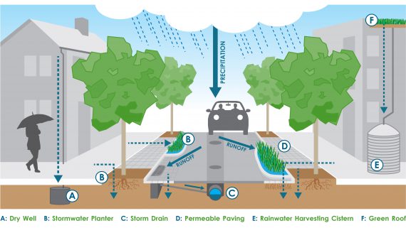
fig2: https://tomorrow.norwalkct.org/wp-content/uploads/2019/11/Green-infrastructure.jpg
3. How can green infrastructure lead to urban regeneration?
While GI is crucial for maintaining ecology, we also need to direct it to connect nature and the community by designing areas that foster connectedness, accessibility, physical activity, education, social cohesion, and other desired functions (Mell 2009). Next, I will introduce two pertinent case studies.
3.1 The big “U”
The BIG U surrounds Manhattan’s waterfront from West 54th Street to East 40th Street in a ribbon of protective landscapes that safeguard communities from storms and sea level rise while also delivering much-needed cultural, recreational, and socioeconomic advantages.
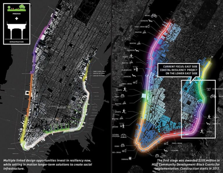 fig3: https://oss.gooood.cn/uploads/2017/03/2016-asla-BigU_4-1-960x742.jpg
the BIG U focused on three compartments hardest hit by Hurricane Sandy. In the C1 region, An undulating topography is created by a 15-foot high riverbank that winds its way to River East Park while protecting the neighbourhood and highway behind it. The waterfront environment is improved, and the neighbourhood is connected, by new footpaths, bike lanes, and footbridges along the embankment. Upland, the landscape design uses bioswales and rain gardens to create green corridors that lead to park entrances while also enhancing the neighbourhood’s urban experience.
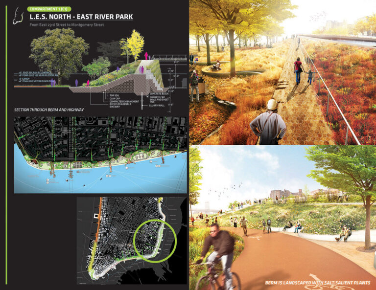
fg4: Bridging berm features wide landscaped bridges and highlights the potential for enhanced recreational value for a neighbouring housing
C2 combines movable flood barriers that protect against wave action and storm surge with a continuous, curved 4-foot bench that spans the Manhattan and Brooklyn Bridges, offering protection during less severe storms. The low-profile bench creates additional venues for entertainment, markets, social services, and more while preserving views of the river. In a longer-term plan for the region, the landscape architect would weave a berm system through the campuses of the public housing complexes, giving them character and transforming them into flood-protective landscapes that manage stormwater and incorporate recreation, agriculture, social services, and economic opportunities.
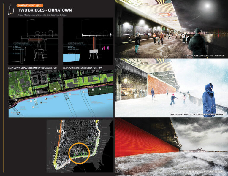
fig5: A series of flip-down, deployable panels stored beneath the road creates an overhead public art canopy, sheltered spaces
C3 has enormous economic and cultural significance for both the city and the country. One of the nation’s most recognisable open spaces is revitalised at The Battery with a new landscape of berms and integrated cultural amenities while safeguarding its important financial district. Deployable barriers, low walls, and berms combine to form a multi-layered storm defence system beneath the FDR Drive that protects vital infrastructure and shelters the neighbourhood.
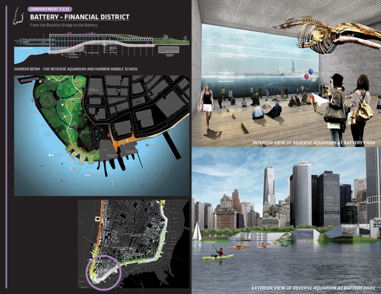
fig6: A sweeping arc of high ground will prevent water from inundating the sensitive Financial District and enhance this iconic open space with an improved bikeway and archipelago of new cultural attractions and thematic gardens
3.2 Pailao Riverside Masterplan in Shenzhen
A new masterplan along the central Pailao River in Shenzhen proposes a climate-proof regeneration of the area, using nature and water retention ecological zones to mitigate the risk of flooding. To future-proof their master plan, the VenhoevenCS team used water to create an innovative design. The construction of ponds, green roofs, more space for trees, urban farming, new parks, wetlands, and soft banks are just a few interventions that organise water storage and establish the new identity of Bao’an.
The network of rivers that run to the sea and the crowded metropolitan centres that lie in between were taken into account when analysing the Blueway Project. The climate-adaptive remodelling of these neighbourhoods and their public space became vital to the strategy. Grey land is transformed into green space, with water serving as the region’s defining feature. Changes in mobility also occur when there is more room for nature. With mobility hubs, effective public transportation, and a vast network for local, slow traffic, Bao’an is still reachable.
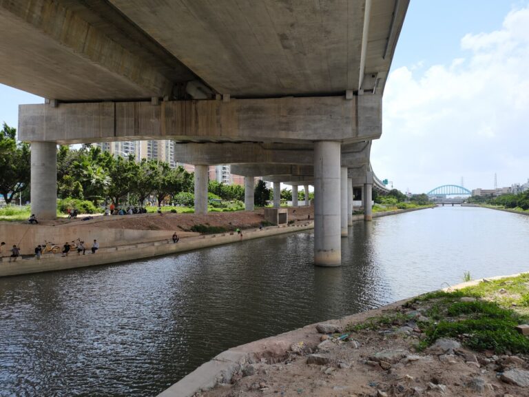
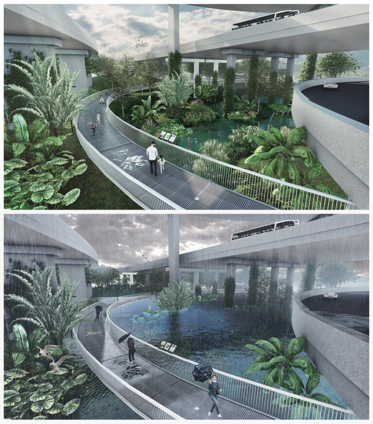
fig7:https://www.archdaily.com/971318/a-riverside-masterplan-in-shenzhen-is-designed-to-prevent-flooding/6182cc980b29824ed21a0c78-a-riverside-masterplan-in-shenzhen-is-designed-to-prevent-flooding-photo
Wide, soft banks that naturally absorb water will take the place of the Pailao River’s concrete quays. The riverside will be punctuated by several parks, providing space for pedestrians. Under the viaducts, bridges for traffic now have additional gathering spots and public areas. Pavilions for public meetings are built on stilts to withstand shifting conditions since water levels may ebb and flow here.

fig8: https://images.adsttc.com/media/images/6182/cc97/0b29/822c/7eb8/0ecd/slideshow/06b-pailao-river-shenzhen-venhoevencs-hope-huadong-pavilion-along-the-river.jpg?1635962018

Cities not only have buildings but also various green spaces. This blog introduces the composition of urban green infrastructure and how cities can prevent and control floods. Let me realize that I need to consider more green infrastructure when designing this semester.
As a child, my hometown Chengdu often had water on the roads when it rained[1]. The stagnant water not only affects the mood but also affects the quality of space and traffic. Caused a lot of economic losses[2]. A city’s green infrastructure construction reflects the urban infrastructure level. And from my point of view, all cities should be built with the concept of a sponge city.
I think the urban ecosystem is fragile[3] because the city’s construction differs significantly from the natural environment. Taking soil as an example, the ground in nature is absorbent, and the water that seeps into the ground can nourish plants and reduce flood disasters to a certain extent. Suppose the pavement in the city has a good water seepage function. In that case, it can reduce water accumulation and store water for recycling.
I like the physical projects in your blog very much. In the projects, I feel the series concept of urban green ecology. Like Manhattan’s waterfront project, people, activities, green space, and water are well connected.
Reference:
[1]China Floods Wreak Havoc, Block Roads and Railways; More Rain Due. (2018, July 14). ARABNEWS. https://www.arabnews.com/node/1338601/world
[2]Maria Pregnolato, Alistair Ford, Sean M. Wilkinson, Richard J. Dawson,The impact of flooding on road transport: A depth-disruption function,Transportation Research Part D: Transport and Environment,Volume 55,2017,Pages 67-81,ISSN 1361-9209,https://doi.org/10.1016/j.trd.2017.06.020.
[3] Su M, Zhang Y, Liu G, Xu L, Zhang L, Yang Z. Urban Ecosystem Health Assessment: Perspectives and Chinese Practice. International Journal of Environmental Research and Public Health. 2013; 10(11):5874-5885. https://doi.org/10.3390/ijerph10115874
I was very interested to see the article on green infrastructure. This is because green infrastructure is one of the important research objectives in the graduation project that I want to undertake. This article was very effective in helping me. And it provided me with some inspiration. The impact of urban green infrastructure on a city is multifaceted, such as environmental protection, sustainable use of resources, climate adaptation and resilience to disaster risks, and economic benefits. Good green infrastructure can improve a city’s resilience to natural disasters. It also creates a more aesthetically pleasing, healthy and sustainable urban environment, which contributes to a better quality of life for residents. At the same time, green infrastructure can also provide sustainable and environmentally friendly design concepts and technologies in urban planning and design. It can also contribute to the construction of facilities and systems that promote ecosystem health, sustainable resource use and human well-being. It provides the foundation to support sustainable urban development.
[1] Li Kairan. “Green Infrastructure: Concept, Theory and Practice.” Chinese Garden 10 (2009): 88-90.